

Franciscan convent
Client / Collaborator
Entremise
Sector
Architecture, Patrimoine
Location
Montreal
Services
Relevé LiDAR, Relevé par drone, Photogrammetrie, Modélisation Revit, Visite Virtuelle
Mandate
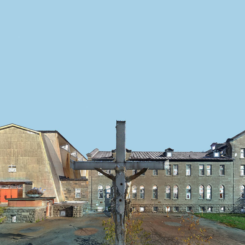
A landmark in Rosemont-Est, Église catholique de la Résurrection and the Franciscan convent are part of a heritage requalification process led by Entremise, with the goal of preserving the character of the site while adapting it to new uses rooted in the needs of the surrounding community.
Within this context, Entremise mandated the complete 3D scanning of the church and convent interiors, exteriors and basement areas in order to create a precise documentation base for Revit models used by the architectural and engineering team, along with a virtual tour for coordination, presentation, marketing and sales purposes.

Mandate
A landmark in Rosemont-Est, Église catholique de la Résurrection and the Franciscan convent are part of a heritage requalification process led by Entremise, with the goal of preserving the character of the site while adapting it to new uses rooted in the needs of the surrounding community.
Within this context, Entremise mandated the complete 3D scanning of the church and convent interiors, exteriors and basement areas in order to create a precise documentation base for Revit models used by the architectural and engineering team, along with a virtual tour for coordination, presentation, marketing and sales purposes.
Proposition
To meet the project’s precision requirements, especially in a built heritage context, a hybrid approach combining LiDAR scanning, drone scanning and photogrammetry is deployed to document the site as a whole.
Control network and coordinate system
A control network is established to provide a robust geometric framework across the property. Distributed throughout the interior and exterior spaces, the control points support spatial consistency, tie together the different capture campaigns and improve the reliability of the data used for 3D scanning and Revit modelling.
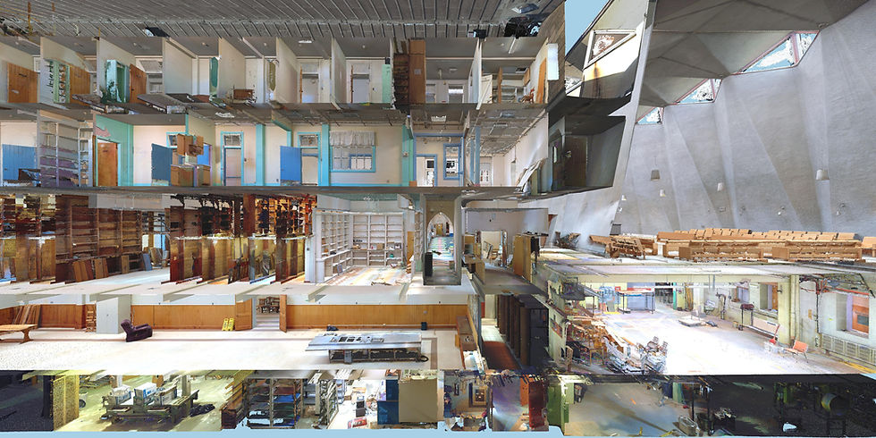
High-density terrestrial LiDAR
A high-density terrestrial LiDAR scan of the building envelope is then completed in order to preserve the visible detail of the historic facades, openings, massing and architectural components. This phase supports an accurate reading of existing conditions while retaining the geometric richness of the heritage building.
Mobile LiDAR (SLAM) constrained by control points
Mobile LiDAR scanning using SLAM technology covers the interior spaces, including the technical and mechanical rooms, in order to create a complete and detailed representation of existing conditions. The SLAM dataset is tied to and corrected by the control network to ensure a coherent and project-ready model of the building.
Drone photogrammetry for roofs
Drone scanning of the roofs is performed through thousands of images processed with photogrammetry and tied back to the control network. This method documents roof surfaces, upper volumes and hard-to-reach areas while completing the overall 3D scanning scope for the site.
Virtual visit
A virtual tour on the Matterport platform is also proposed for its ease of sharing, intuitive navigation and high-definition HDR imagery, which helps reveal detail even in darker spaces. In unlit mechanical rooms, custom-built 3D lighting attached to the scanner is used to capture the visual information required for a clear reading of the spaces and equipment.
Virtual museum
A second virtual tour is proposed to serve as a virtual museum of the portions of the church slated for transformation or demolition. Panoramic images are captured at eye level in both standing and seated positions in order to recreate a more faithful experience of the space, including the perspective from the pews.
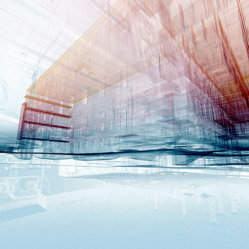
Revit modelling at LOD 200
A Revit modelling scope at Level of Development 200 (LOD 200) is also proposed to provide the architectural and engineering team with a clear, structured and directly usable digital model. This level of development supports the representation of the building’s main systems, volumes and components while helping with studies, interdisciplinary coordination and project planning.
Deliverables
The deliverables include a georeferenced coloured point cloud optimized to reduce duplicate points and facilitate use by project professionals. This point cloud combines all datasets produced through drone photogrammetry, terrestrial LiDAR scanning and mobile LiDAR scanning using SLAM technology.
Two virtual tours are delivered: the first for coordination, communication and marketing purposes, and the second as an online museum documenting the portions of the site that will be transformed or demolished.
An LOD 200 Revit model is also delivered with the main architectural and structural elements, along with built-in furniture, exposed plumbing fixtures, visible electrical fixtures and other essential components required to understand existing conditions.


Behind-the-scenes experience


